Lost password? New user? Register
Enjoy and contribute!
| Find the best spots |
|
|
 Martinique
Central America
Location: Caribbean, island between the Caribbean Sea and North Atlantic Ocean, north of Trinidad and Tobago
Geographic coordinates: 14° 24' N, 61° 0' W
Coastline km: 350 km km
Climate: tropical; moderated by trade winds; rainy season (June to October); vulnerable to devastating cyclones (hurricanes) every eight years on average; average temperature 17.3 degrees C; humid
Terrain: the island is dominated by Mount Pelee, which on 8 May 1902 erupted and completely destroyed the city of Saint Pierre, killing 30,000 inhabitants
Elevation: highest point: Montagne Pelee 1,397 m
Natural hazards: hurricanes, flooding, and volcanic activity (an average of one major natural disaster every five years)
Currency: euro (EUR)
Population: 429,510 (July 2004 est.)
Languages: French, Creole patois
Capital: Fort-de-France
Divisions: none (overseas department of France)
Wanna add some info about Martinique? Let us know...
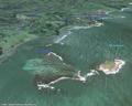
This is an interactive map! Use controls to pan and zoom this map.
- kite sessions (0)
- trips (0)
- Photos (9)
- Videos (0)
- Share
- Favourite
-
Your favourites and future spot lists
Spots
| Spots (2) | Quality | Experience | Type | Amenities | ||
|---|---|---|---|---|---|---|
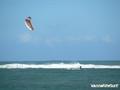
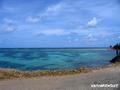
| Luciole | 4 / - | Established | Lagoon | |||
| Pointe Faula | 5 / - | Everyone | Lagoon | 


|

 Comments
Errors, Feedback
If you want to add new information or you have found errors on this country, Send us feedback.