¿Ha perdido la contraseña?
¿Nuevo usuario? Crear una cuenta
¡Disfrute y contribuya!
| Encontrar los mejores spots |
|
|
 Honduras
América Central
Ubicación: Central America, bordering the Caribbean Sea, between Guatemala and Nicaragua and bordering the Gulf of Fonseca (North Pacific Ocean), between El Salvador and Nicaragua
Coordenadas geográficas: 15° 0' N, 86° 30' W
Km de línea costera: 820 km km
Clima: subtropical in lowlands, temperate in mountains
Terreno: mostly mountains in interior, narrow coastal plains
Cumbres: lowest point: Caribbean Sea 0 m
highest point: Cerro Las Minas 2,870 m
Riesgos naturales: frequent, but generally mild, earthquakes; extremely susceptible to damaging hurricanes and floods along the Caribbean coast
Moneda: lempira (HNL)
Población: 7,326,496
Lenguas: Spanish, Amerindian dialects
Capital: Tegucigalpa
División administrativa: 18 departments: Atlantida, Choluteca, Colon, Comayagua, Copan, Cortes, El Paraiso, Francisco Morazan, Gracias a Dios, Intibuca, Islas de la Bahia, La Paz, Lempira, Ocotepeque, Olancho, Santa Barbara, Valle, Yoro
¿Quiere añadir más informacion sobre Honduras? Háganos saber...
¡Este es un mapa interactivo! Use los controles para recorrerlo y hacer zoom.
- Favoritos
-
Sus listas de spots favoritos y futuros
Spots
| Spots (1) | Calidad | Experiencia | Tipo | Comodidades | ||
|---|---|---|---|---|---|---|
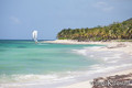
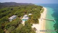
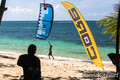
| Camp Bay Beach | 3 / - | Todos | Playa | 


|
 Comentarios
Sea el(la) primero(a) a hacer un comentario sobre este país
Errores, opiniones.
Si quiere añadir nueva información o si ha encontrado errores en esta país, Envíe sus observaciones